Watch the Med
Development WTM site7 people die, and 2 missing near the Greek island of Lesvos
18.03.2014 / 13:51 / Korakas cape, Lesbos Isl. (Gr)
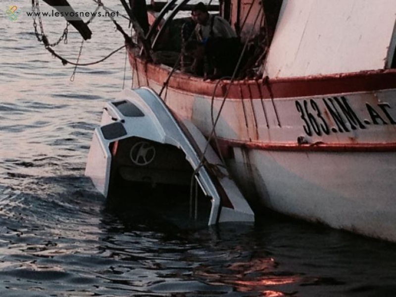
On Tuesday 18 of March, the Main SAR coordination centre of Ankara informed the Greek authorities about a shipwreck that occured 1,5 miles off the Korakas cape, in the Northeast of the island of Lesvos/Greece. 2 people were already rescued by a cargo ship, before the Greek coast guard arrived. 7 people were found dead, 2 missing and 8 people survived. Three coast guard vessels, a helicopter and private boats were involved in the search and rescue mission. The boats “Theofilos” and “Gas Puffer” were also in the area. The survivors were brought to the Mytilene hospital, while the semi sunk boat was drawn into the port of Mytilene (see picture).
http://www.theguardian.com/world/2014/mar/18/migrants-drown-greek-coast-lesbos-aegean-sea?CMP=twt_gu
http://www.thepressproject.net/article/58423/Women-and-children-among-seven-immigrants-to-die-in-latest-Aegean-tragedy---two-still-missing
http://www.lesvosnews.net/articles/news-categories/koinonia/mytilini-aneipoti-tragodia-me-7-nekroys
http://www.nytimes.com/2014/03/19/world/europe/migrants-drowned-trying-to-reach-greece.html
Last update: 17:36 Aug 13, 2014
Sources
http://www.ekathimerini.com/4dcgi/_w_articles_wsite1_1_18/03/2014_538248http://www.theguardian.com/world/2014/mar/18/migrants-drown-greek-coast-lesbos-aegean-sea?CMP=twt_gu
http://www.thepressproject.net/article/58423/Women-and-children-among-seven-immigrants-to-die-in-latest-Aegean-tragedy---two-still-missing
http://www.lesvosnews.net/articles/news-categories/koinonia/mytilini-aneipoti-tragodia-me-7-nekroys
http://www.nytimes.com/2014/03/19/world/europe/migrants-drowned-trying-to-reach-greece.html
| Credibility: |  |
 |
0 |
Related Reports
16:02 Mar 29, 2021 /
Aegean Sea Kms
28/03: 40 travelers in distress north of Lesvos, rescued by Turkish coastguard
15:34 Apr 30, 2020 /
Aegean Sea Kms
29/04: Greek coastguard pushes 48 protection seekers back to Turkey
16:04 Jul 28, 2015 /
Aegean Sea, near Lesvos Kms