Watch the Med
Development WTM siteLeft-to-die boat
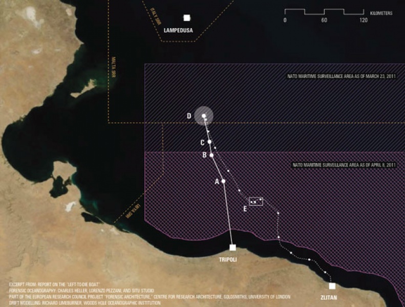
10.04.2011 / 12:19 / Central Mediterranean
The migrants’ vessel left the Port of Tripoli between 00:00 and 02:00 GMT on 27 March 2011 with 72 migrants on board. The vessel was sighted by a French aircraft which transmitted its coordinates to Rome MRCC. After proceeding in the direction of Lampedusa for 15 - 18 hours, the migrants placed a distress call by satellite phone to an Eritrean priest based in Italy. The priest, in turn, called the MRCC in Rome to alert them to the fact that there was a vessel in distress. Shortly following this call, the MRCC in Rome published an Enhanced Group Call message and alerted both Malta MRCC and NATO HQ allied command in Naples that a vessel was in distress. It also provided them with the vessel’s geographic coordinates at 16:52 GMT. Following the broadcast of the vessel’s position, a helicopter baring the writing "ARMY" arrived, observed the boat and left. After this visit by the helicopter, the position of the boat was determined a second time as 9 nautical miles NNW of the earlier position. The migrants then waited 4 - 5 hours in the same area, where their requests for help from some fishermen went unheeded. Still in the same position, the vessel was visited for a second time by a military helicopter that dropped biscuits and water before leaving. The vessel then continued NNW towards Lampedusa for 5 – 8 hours before running out of fuel at approximately 07:00 GMT on 28 March, at which time the boat began to drift. The boat drifted SSW for 7 - 8 days before it encountered a military ship. On 10 April, the boat landed south- east of Tripoli at Zlitan. Upon landing, 11 migrants were still alive. 2 died shortly thereafter.
Several legal proceedings have been filed by a coalition of NGOs to demand accountability for the fate of the passengers. A legal complaint “against persons unknown” was initially lodged before the section of the Paris High Court (Tribunal de grande instance) specializing in military cases in April 2012, after a similar procedure in Italy. After the decision of the Paris Prosecutor’s Office to take no action on this initial complaint, the survivors and the NGOs initiated proceedings in France and Spain as civil parties, in a way that will force the opening of judicial investigations. Freedom of Information requests have been submitted in Canada, the US, and the UK.
Despite several investigations into to this incident and repeated inquiries, the identity of the helicopter(s) and the military vessel that entered into direct contact with the migrants has not been revealed.
On the 28th of november 2013, three survivors of this tragedy, filed a complaint at the Brussels Tribunal of First Instance against the Belgian army for failing to provide assistance to persons in distress.
http://www.fidh.org/63-migrants-left-to-die-in-the-mediterranean-survivors-continue-their-13484
http://assembly.coe.int/CommitteeDocs/2012/20120329_mig_RPT.EN.pdf
http://www.fidh.org/en/migrants-rights/14293-63-migrants-left-to-die-in-the-mediterranean-survivors-file-a-complaint
Several legal proceedings have been filed by a coalition of NGOs to demand accountability for the fate of the passengers. A legal complaint “against persons unknown” was initially lodged before the section of the Paris High Court (Tribunal de grande instance) specializing in military cases in April 2012, after a similar procedure in Italy. After the decision of the Paris Prosecutor’s Office to take no action on this initial complaint, the survivors and the NGOs initiated proceedings in France and Spain as civil parties, in a way that will force the opening of judicial investigations. Freedom of Information requests have been submitted in Canada, the US, and the UK.
Despite several investigations into to this incident and repeated inquiries, the identity of the helicopter(s) and the military vessel that entered into direct contact with the migrants has not been revealed.
On the 28th of november 2013, three survivors of this tragedy, filed a complaint at the Brussels Tribunal of First Instance against the Belgian army for failing to provide assistance to persons in distress.
Last update: 15:17 Jul 14, 2014
Sources
http://www.forensic-architecture.org/investigations/forensic-oceanography/http://www.fidh.org/63-migrants-left-to-die-in-the-mediterranean-survivors-continue-their-13484
http://assembly.coe.int/CommitteeDocs/2012/20120329_mig_RPT.EN.pdf
http://www.fidh.org/en/migrants-rights/14293-63-migrants-left-to-die-in-the-mediterranean-survivors-file-a-complaint
| Credibility: |  |
 |
0 |
Additoinal Documents
Related Reports
18:07 Jul 27, 2020 /
Central Mediterranean Kms
26/07: 45 people rescued by Italian coast guard, fate of 85 people unclear
12:52 Oct 06, 2020 /
Central Mediterranean Kms
05/10: Five people in distress in Maltese SAR, one dialysis patient returned to Tripoli
22:52 Oct 11, 2013 /
Central Mediterranean Kms
Over 200 die after shooting by Libyan vessel and delay in rescue
09:45 Mar 31, 2021 /
Central Mediterranean Kms
30/03: 20 people, including one pregnant woman and 10 children crossed the Central Mediterranean and made it to Lampedusa
16:37 Jul 04, 2021 /
Central Mediterranean Sea Kms